Tricks and Treats in Long Island City this Halloween weekend

Get the kiddies dressed up for LIC’s Annual Halloween Parade!
Thursday 10/28
LIC’s favorite event space The Foundry is kicking off Halloween activity with a Starving Artists Halloween Ball on Thursday, Oct 28th, 8pm-midnight. 42-38 9th St, LIC
Court Square Wine & Spirits hosts FREE wine tasting events every Thursday & Friday of the week from 4:30-7:00pm. 2420 Jackson Ave, LIC, 718.707.9911
Saturday 10/30
Kitty Dog Lounge, Breadbox Cafe & Modern Spaces are hosting a LIC Halloween Dog Parade on Saturday from 4-5:30pm on Saturday, Oct 30th. Prizes for the best dog costume! 47-11 11th St, LIC
The Ravel Hotel is hosting Hotel Massacre a rooftop experience at the Haunted Penthouse 808 on Sat, Oct 30th at 10pm. 808 Queens Plaza South
The Secret Theatre presents an evening with three-time Grammy nominated Peter Case with Steve Goulding + Very Special Guests Little Embers + Live ‘In The Actors Studio’ Interview with Director/Producer Richard Mazda. October 30th, Doors @ 6pm, $25. Available online or call 718 392 0722.
Scare the kiddies nice and early on Halloween in LIC!
Sunday 10/31 HALLOWEEN
The Annual LIC Halloween Parade is happening again this year, when else? On Sunday, Oct 31st, the parade starts at LIC Kids, at 3:30pm and continues until the evening at various participating restaurants including Cranky’s Cafe, Manducatis Rustica, and Plaxall’s corner space where Little Closets used to be. See the full PDF for schedule and route detail.
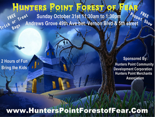
There’s also a Haunted House in LIC this year! Hunters Point Forest of Fear is being hosted at Andrews Grove playground from 11:30am to 1pm, courtesy of the Hunters Point Merchants Association. 49th Ave between Vernon Blvd & 5th St
And to round out the night, The Queens Players present Halloween Fright Club, the annual Halloween costume party @ the Secret Theatre. $15 includes prizes and one free drink. Watch out for the guillotine. Sunday, Oct 31st, 8pm. 4402 23rd St, LIC
Week of Nov 1st – 4th
- Hunters Point Restaurant Week is happening from Nov 1-4th, with participating restaurants offering prix fixe dinners for $25, including appetizer, entree & dessert: Riverview, Dorian Cafe, Lounge 47, Madera, SHI, Cafe Henri, Ihawan 2, Masso, Testaccio, Jackson Ave Steakhouse, and Manducatis Rustica.
Upcoming Events »
 Events
Long Island City weirdly warm and dreary Thursday afternoon linkage
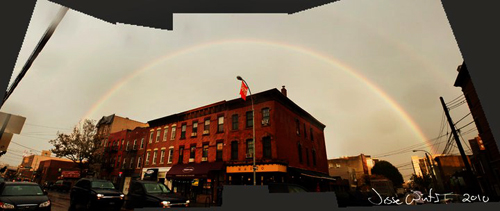
A rainbow graced Vernon Blvd yesterday, LIC. –photo by Jesse Winter
.
The Queenswest MTA exhaust fan to be muffled by politicians (ha, if only) [NY Daily News]
UES condos marketing agains LIC & Williamsburg condos [NY Post]
Do you dare to brave the waters of Newtown Creek? [Newtown Pentacle]
Spa expands into LIC’s Queenswest waterfront [City Biz List]
LeFooding event at LIC’s PS1 MoMA causes controversy [Village Voice]
Review of Secret Theatre’s Julius Caesar [BlogCritics]
LIC’s Citigroup accused of wrongfully sacking women [Daily Mail]
Catching up on CB2 goings-on [Queens Gazette]
LIC showing signs of rebounding [Market Wire]
MTA surveillance cameras coming to LIC [NY Post]
New swimming program for autistic children at the LIC YMCA [Queens Courier]
LIC is the next big neighborhood (again) [Daily News]
Astoria/LIC residents clean up local parks with Green Shores NYC [Queens Gazette]
Dutch Kills Civic Association celebrates 30 years [Queens Gazette]
Sweetleaf expansion rocks LIC’s coffee world [NYT Blog]
Linkage 
Long Island City weekly event round-up; Sept 23rd – 26th
Check out a very special LIC photo exhibition this weekend at TEN10 Studios
Thursday 9/23
- Court Square Wine & Spirits hosts FREE wine tasting events every Thursday & Friday of the week from 4:30-7:00pm. 2420 Jackson Ave, LIC, 718.707.9911
Friday 9/24
TEN10 Studios is hosting a special artist exhibit entitled ‘Amelia’s Photos‘ this weekend, opening party onFriday, Sept 24th. from 6-10pm. Exhibition continues Sat & Sun from 12 – 6pm. 10-10 47th Rd, LIC
Court Square Wine & Spirits hosts FREE wine tasting events every Thursday & Friday of the week from 4:30-7:00pm. 2420 Jackson Ave, LIC, 718.707.9911
LIC’s Queens Players present ‘Julius Caesar’ by William Shakespeare, directed & produced By Richard Mazda. September 24,25,26,29,30 & October 1,2 @ 8PM Matinee September 25 @ 3PM. Tickets $15 Adv $18 Door. The Secret Theatre, 44-02 23rd St., LIC, 718 392 0722
Saturday 9/25
- The Kitty and Dog Lounge will be holding an adoption event this Saturday (9/25) from 1:30-6:00pm. ‘Save Kitty LIC’, a local cat rescue and adoption organization, will have cats and kittens available for adoption most Saturdays in LIC. “All of our cats are rescues from LIC and Astoria. We would like to see as many as possible obtain new and loving forever homes here in their own neighborhood, and if people can’t adopt we encourage them to provide a temporary foster home for a cat or kitten in need.” 49-02 Vernon Blvd, LIC
Sunday 9/26
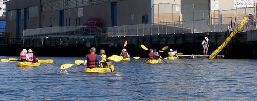
- Long Island City Community Boathouse is hosting their weekly Hallets Cove Public Paddle every Sunday from 1-5pm. Free walk-up paddling (no reservation needed). All ages, but under 18 must be accompanied by a parent or guardian. Wear clothing and footwear that can get wet. Meet at Vernon Blvd and 31st Avenue, adjacent to Socrates Sculpture Park.3105 Vernon Blvd, LIC
Events 
Long Island City jazzy Monday afternoon linkage
And the band plays on. LIC Bar, Vernon Blvd. –photo: Ciprian Toma
.
Speaking out in LIC against sex trafficking at Queens [Astoria Times]
Photo survey of Dutch Kills LIC [Newtown Pentacle]
Love on the Ravel Hotel in LIC [NY Post]
LIC’s JetBlue showing NYC love in new logo [PR Release]
Disgruntled cabbies in LIC being taken for a ride themselves [NY Post]
LIC brokers & artists teaming up to sell condos & art [Daily News]
Amazon buys LIC’s local biz Amie Street [Technology Review]
Linkage 
Long Island City supremely gorgeous Thursday morning linkage

Abstract Autumn Dreaming on the wall of 5pointz, LIC -photo: Ciprian Toma
.
Queens restaurant week starts next week [Discover Queens]
Checking out LIC’s new burger garage [Foodista]
Visiting Ravel Hotel’s Penthouse 808 [Finance Foodie]
M.Wells still killing it in LIC [Glenwood NYC]
Review of LIC’s Madera Cuban Grill [Queens Gazette]
Permit parking for LIC? Dare to dream. [Times Union]
Maloney easily wins primary, for UES & Western Queens Rep [Queens Courier]
Linkage 
Long Island City weekly event round-up; Sept 8th – 12th

LIC’s Ethereal Boutique hosts Fashion’s Night Out event, Friday Sept 10th, LIC
Wednesday 9/8
The LIC Greenmarket happens every Wednesday now, until November 24th, from 8am-6pm. 48th Ave & Vernon Blvd, Hunters Point, LIC
Shi Restaurant hosts karaoke on Wednesday nights. 4720 Center Blvd, LIC, 347.242.2450
Thursday 9/9
- Court Square Wine & Spirits hosts FREE wine tasting events every Thursday & Friday of the week from 4:30-7:00pm. 2420 Jackson Ave, LIC, 718.707.9911
Friday 9/10
LIC’s Ethereal Boutique will be celebrating Fashion Night Out with a chic party including: live DJ, Winter Santos (named the hottest Latina DJ of NYC by the New York Post) – gallery opening featuring dazzling bi-coastal artist Sarah J. Dahl who illustrates for Joseph Abboud – trunk show by two new upcoming designers Sarah and Suruzi founders of The Blank – we will have refreshing cocktails and scrumptious hors ‘doeuvres served by stylish gentlemen. Festivities & shop-a-thon begins at 5:30pm. 47-38 Vernon Blvd, LIC
Come celebrate LIC’s only Michellin rated restaurant, SHI’s 2 year anniversary in LIC on Friday, Sept 10th with Ketel One Promotions at 10pm. 4720 Center Blvd, LIC, 347.242.2450
Court Square Wine & Spirits hosts FREE wine tasting events every Thursday & Friday of the week from 4:30-7:00pm. 2420 Jackson Ave, LIC, 718.707.9911
Saturday 9/11
- SHI restaurant is hosting a special night of Flip Me Dating Promotions at 10pm. 4720 Center Blvd, LIC, 347.242.2450
Sunday 9/12
- Long Island City Community Boathouse is hosting their weekly Hallets Cove Public Paddle every Sunday from 1-5pm. Free walk-up paddling (no reservation needed). All ages, but under 18 must be accompanied by a parent or guardian. Wear clothing and footwear that can get wet. Meet at Vernon Blvd and 31st Avenue, adjacent to Socrates Sculpture Park.3105 Vernon Blvd, LIC
Events
What Long Island City did on our summer vacation; linkage galore
Hello liQcity readers, we’re back. Glad everyone kept themselves occupied in the summer heat. Enjoy the catch-up linkage, and of course the cool breezes headed our way, especially in those LIC new spots opening up this Fall. Stay tuned for our usual biz updates, but in the meantime check out some teasers in the linkage. (There’s so much news to catch up on, much of it is after the jump.)
Local Biz
Quick scoop on LIC’s latest new bar/restaurant at Anable Basin [Gothamist]
The near fall and consequent rise of LIC’s Fresh Direct [NYT]
M.Wells puts a new spin on diner food [Foodista]
Real Estate
Trouble in paradise at the LIC’s Arris Lofts [Curbed]
More than half of Arris Lofts’ buyers suing developer in class action suit [Crains]
New condo buyer back-outs successful in FiDi, not LIC [Curbed]
NYC & LIC brokers getting creative to attract buyers [Inman]
NYC real estate flips & splits, including LIC [NY Daily News]
More General LIC linkage »
Linkage
Long Island City catching up with Wednesday afternoon linkage
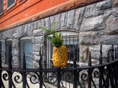
A new way of incorporating pineapple into architecture, LIC –photo
Hello liQcity readers – August posting will be light. Even we have to go on vacation sometimes, especially when it’s 100 degrees. Or so. We’d like to take this opportunity to remind everyone to send us your local events, especially if they are free and open to the LIC public. We need all the details by the Friday before the week of the event in order to post it. Cheers.
M.Wells Diner really knocked it out of the park [NY Press]
Montreal gets wind that LIC has captured one of their chefs [Montreal Gazette]
Cop from LIC’s 108th precinct shoots lover [Gothamist]
PS1 is LIC’s photo du jour [NY Shitty]
More waxing on the history of Newton Creek [Newtown Pentacle]
Police night against crime in LIC [Queens Chronicle]
LIC’s first mascot lizard at Gantry Park [NY Shitty]
Vintage tugboat on Newtown Creek [Newtown pentacle]
Checking out LIC/Sunnyside’s railyards [Newtown Pentacle]
Linkage 
Long Island City weekly event roundup; August 3rd – 8th
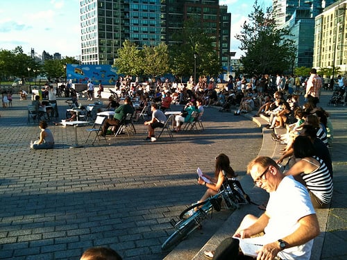
Chillin at QCA’s ‘Live at the Gantries’ Summer Music Festival 2010, LIC
Tuesday 8/3
- Live at the Gantries, LIC’s only outdoor summer music festival sponsored by the QCA, continues on Tuesday, Aug 3rd with the St. Paul AME Church Mass Choir, “Powerful Gospel Music”. 7pm at the Gantry State Park, LIC waterfront. 50th Ave & the East River
Wednesday 8/4
The LIC Greenmarket happens every Wednesday now, starting July 7, from 8am-6pm. 48th Ave & Vernon Blvd, Hunters Point, LIC
Socrates Sculpture Park’s Outdoor International Film Series 2010 runs Wednesday evenings in July & August. Pre-screening performances begin at 7pm, films begin at sunset. Food provided by local international restaurants. Free admission. 32-01 Vernon Blvd, LIC
Shi Restaurant hosts karaoke on Wednesday nights. 4720 Center Blvd, LIC, 347.242.2450
Thursday 8/5 »
Events 
Long Island City Tuesday slightly sunny afternoon linkage
Still life in Long Island City. — photo by Newtown Pentacle
.
A slice of old school LIC [Newtown Pentacle]
LIC deli gets NYC Health Dept’s first Grade A [Crains]
All you can eat Gnocchi at LIC’s Testaccio [Foodista]
Man accused of burglarizing LIC businesses [Your Nabe]
LIC summer camp gets city girls in touch with city nature [Your Nabe]
Review of Socrates Sculpture Park’s outdoor international film series [Your Nabe]
LIC’s East of East Condo unveils with ribbon cutting ceremony [Curbed]
Assessing Queens’ schools’ students’ performance relative to the country [NY Daily]
The Burger Garage opened yesterday in Court Square [The Burger Garage]
Linkage
LIC’s Hunters Point library site in lawsuit over remediation costs
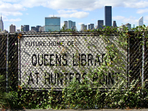
From Crains:
Plans for a 20,000-square-foot library in Long Island City, Queens, along the East River, are moving ahead in a timely fashion, despite a possible lawsuit involving who should pay for the clean-up of the site.
The state’s Queens West Development Corp. said it plans to sue Honeywell International to pay for the $5 million to $10 million clean-up of toxic waste on the three-quarter acre plot at Center Boulevard between 48th Avenue and 47th Drive. The state claims that a Honeywell predecessor firm used the site to make and store roofing materials, and says it will sue because yearlong negotiations with the company have broken down »
Neighborhood 
Long Island City weekend update; Queens Plaza moving into the future
Queens Plaza in the beginning stages of a complete makeover, Long Island City.
LIC links
Queens Plaza renovations a boon for bicyclists [Streetsblog]
LIC’s old school fireboxes crumbling [Newtown Pentacle]
LIC’s Dutch Kills’ residents gather to discuss future of their hood [Your Nabe]
More noise in LIC [Queenscrap]
Roundup of the QCA local artist grants [Queens Tribune]
The ‘Green Girls’ visit LIC’s Hallets Cove [QNYC]
Weekend Event Update
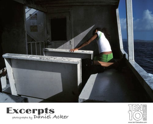
- Ten10 Studios is still hosting the opening party of its fifth exhibition of the summer, “Excerpts” by Daniel Acker, continuing though tonight (Saturday) from 6-10:10pm. The studio is open to the street, and right next to the Yoga Room at Vernon Blvd. liQcity rates 5 stars for great vibe. Check out photos from their space. 1010 47th Rd, LIC, 646.271.5353
Linkage 
Long Island City weekly event roundup: July 22nd – 25th
Ten10 Studios host opening party tonight for ‘Excerpts’, Long Island City
Thursday 7/22
Ten10 Studios hosts the opening of its fifth exhibition of the summer, “Excerpts” by Daniel Acker, tonight from 6-10:10pm. The show will highlight Acker’s personal photographs made locally and abroad during the past decade. 1010 47th Rd, LIC, 646.271.5353
Court Square Wine & Spirits hosts FREE wine tasting events every Thursday & Friday of the week from 4:30-7:00pm. 2420 Jackson Ave, LIC, 718.707.9911
Friday 7/23 »
Events
Summer opportunities
Welcome to the Local Project, Gallery & Studio in 5pointz building, LIC
Long Island City has for a long time now been known for hosting NYC’s largest artist colony outside of Manhattan (where is it now, Chelsea?). We haven’t heard much about LIC’s artist community in a while, since the Crane Street Studios closed due to a tragic accident, and a beloved local artist was brutally murdered by her ex-boyfriend, but finally it’s some good news! The government would like to give you guys some money to make art in LIC. Ok local artists, pay attention »
Arts
Long Island City producing cupcakes & girl power; M.Wells open for lunch
Long Island City’s Gantry Park part of ‘Play Me I’m Yours NYC’ exhibit. –photo
.
Profile of the latest exhibit at Sculpture Center [Art Info]
CSA options for Long Island City [LICNYC]
The story of LIC’s Fresh Direct [MinyAnville]
LIC’s M.Wells Diner now serving lunch [Foodista]
Humans and dogs co-existing in NYC [Queens Chronicle]
LIC’s cupcake factories fare well with NYC sweet touths [NBC NY]
Spotlight on LIC charity ‘Hour Children’ [Latinalista]
Girl power in LIC [NY Daily]
Luckily, there are many pest management headquarters in LIC [Gothamist]
Linkage
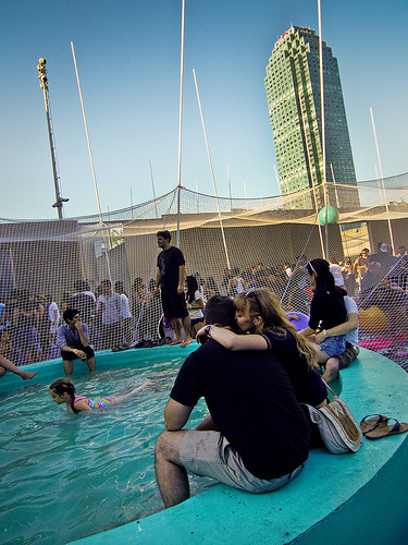
Long Island City morning linkage; Queens Drinks at LIC Boathouse
Long Island City Community Boathouse 2010, Anable Basin, LIC waterfront
.
Queens Drinks & LIC Community Boathouse waterfront party tonight [LICCB]
LIC’s Brooklyn Grange Farm joins forces with Astoria’s Vesta [Foodista]
Gossip girl cast strolling around LIC [Celebrity Gossip]
MIA fights the power at PS1 MoMA [Art Info]
LIC’s Flux Factory offers ‘adventure as performance art’ [Ode Magazine]
Queens through the ages [New Yorker]
Richard Meier’s museum in LIC [Wallpaper]
Checking out LIC’s Cuban grill joint Madera [Queens Courier]
Stuff happening in LIC’s Queensbridge Park [Local 718]
Lots of love for LIC’s new M. Wells Diner [Village Voice]
LIC expanding its coverage as a local commuter hub [Queens Gazette]
Truth in the race to represent Western Queens & UES [Queens Gazette]
VIDEO: Exploring LIC’s Brooklyn Grange rooftop farm [Village Voice]
The Quiet City: exploring NYC’s industrial underbelly [Urban Omnibus]
Real estate sales in Queens see a huge jump in volume [Real Deal]
Linkage 
Long Island City weekly event round-up; July 14th – 18th
Hunters Point Greenmarket, Long Island City –photo:Jesse Winter
Wednesday 7/14
The LIC Greenmarket happens every Wednesday now, starting July 7, from 8am-7pm (!). 48th Ave & Vernon Blvd, Hunters Point, LIC
Socrates Sculpture Park’s Outdoor International Film Series 2010 runs Wednesday evenings in July & August. Pre-screening performances begin at 7pm, films begin at sunset. Food provided by local international restaurants. Free admission. 32-01 Vernon Blvd, LIC
Thursday 7/15 »
Events
LIC’s new M. Wells Diner razzles
Breakfast at the M. Wells Diner. Long Island City — photo:Jesse Winter
Ok Long Island City, you’re going to love this place. There’s been many a request by liQcity commenters for more independently operated specialty restaurants, hold the fusion please. Well, it’s fusion, but not anything anyone in LIC could have even known to ask for. Quebecois food is here! How do you say woohoo! in French-Canadian? »
Local Biz
Long Island City summer heatwave continues Monday morning linkage
Long Island City’s classic architectural mish-mosh.
.
LIC waterfront proposal by Green Shores [Queens Gazette]
Queens Plaza improvements outlined at LICBID annual meeting [Queens Gazette]
Live storytelling in LIC [Queens Courier]
Apples, Bannas & Pears, Oh My…??? Hilariousness in LIC. [Find Jobs in NY]
JetBlue keeping LIC cool [Your Nabe]
The City won’t fix LIC’s broken seawall [Your Nabe]
LIC Solar Energy company greening NYC [CE Center]
LIC residents protest 9-story hotel [The Real Deal]
Kids Day at Noguchi Museum in LIC [A Child Grows]
Review of Socrates Sculpture Park’s outdoor movie night (Wed through Aug) [Capital NY]
Brooklyn Grange redefines local farming in LIC [Well&Good NYC]
Love for Sage General Store in LIC [Coffee Beaners]
LIC’s Con Ed taking unfair heat [Crains NY]
Updated menu for LIC’s Breadbox Cafe [Taste as You Go]
Checking out LIC’s Communitea [Coffee Beaners]
Linkage 
Your salad may have been grown in Long Island City.
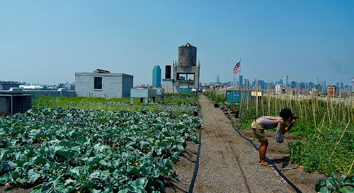
Brooklyn Grange rooftop farm, Long Island City –photo:Jesse Winter
Standard Motors has a farm, EE-I-EE-I-O… Long Island City celebrated the success of its first rooftop farm this week, with a ribbon cutting ceremony attended by local press & politicians. The farmers, Brooklyn Grange, jumped through many hoops to sow their rooftop farm and are starting to see the fruits of their labor. Luckily, so are we.
The one-acre farm on the roof of the Standard Motors building on Northern Blvd is impressive to say the least. Growing speciality vegetables, the farm is already selling to prominent restaurants in the city, as well as their own market in the SM lobby, and can barely keep up with their abundant bounty. So far they’re growing: kale, spinach, rainbow swiss chard, basil, thai basil, mint, cilantro, mustard mix, green salad mix, mizuna, merlot lettuce heads, crispino lettuce heads, bok choy, komatsuna, Italian dandelion and coming soon, cucumbers and puntarelle.
By popular demand »
Neighborhood
Long Island City ridiculously sweltering Wednesday morning linkage

Hang in there Big Allis. Ravenswood, Long Island City
.
LIC’s Con Ed bracing for power demands during heat wave [NYT]
M.Wells diner is open in LIC, from 7am – noon [Foodista]
Lots of love for M.Wells diner, opened yesterday (bfast only) [ChrisAbraham]
Harnessing the power of rye in LIC [Village Voice]
A slice of LIC’s industrial side [Newtown Pentacle]
Plays happening at Cranky’s Cafe [Unity Stage]
Discovering LIC’s Gantry Park [MNYCP]
PS1 WarmUp 2010 coverage [Metromix]
Linkage 
Long Island City’s PS1 MoMA puts the ‘art’ in party with summer WarmUp 2010
PS1 MoMA Summer WarmUp 2010, Long Island City — photo: Jesse Winter
It was a HOT Independence Day weekend, probably one of the hottest in a while. And Long Island City, with its mostly low-to-the-ground industrial landscape really just bakes in the inferno. (El infierno is more like it.) Well our favorite, world-reknowned contemporary art museum PS1 MoMA gave us a brief respite from the heat, with an adult version of a sprinkler set in this weekend’s kick-off to the very popular summer WarmUp music festival, featuring the latest courtyard installation ‘Pole Dance‘. liQcity’s newest roving photographer and blogger Jesse Winter was there to capture the vibe, some great photos, and a video »
Arts
Long Island City weekly event roundup; July 5th – 11th
Socrates Sculpture Park’s Outdoor International Film festival, Long Island City
Tuesday 7/6
-
Live at the Gantries, LIC’s only outdoor summer music festival sponsored by the
QCA, continues on Tuesday, July 6th with
Jia-Yi He,
“A world-class harmonica virtuoso”. 7pm at the Gantry State Park, LIC waterfront.
50th Ave & the East River
Wednesday 7/7
The LIC Greenmarket happens every Wednesday now, starting July 7, from 8am-7pm (!). 48th Ave & Vernon Blvd, Hunters Point, LIC
Socrates Sculpture Park’s Outdoor International Film Series 2010 begins Wed, July 7th. The 12th Annual Festival of International Film, Music, Dance and Food Celebrating the Cultural Diversity of Queens runs Wednesday evenings in July & August. Pre-screening performances begin at 7pm, films begin at sunset. Food provided by local international restaurants. Free admission. 32-01 Vernon Blvd, LIC
Thursday 7/8 »
Events
Long Island City Laughing Buddha on LSD Friday morning linkage
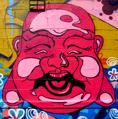
The Laughing Budda is tripping out! 5pointz detail, Long Island City -photo
Actually, we’re tripping out a bit also, at how much LIC news there is this morning. You might want a cup of coffee on hand… this could take a while.
PHOTOS: Miss Heather prowls around 5pointz [NY Sh*tty]
LIC High School targeted for a make-over [Your Nabe]
LIC’s Irish Center involved in 50-year Irish Jubilee celebration [Irish Central]
LIC/Astoria bid adieu to the W train [Your Nabe]
Queens irate over MTA service cuts [Your Nabe]
Little Closets has a slew of LIC kids’ shirts in stock [LC blog]
Holy Sh*t! The Queensbridge Park seawall falling apart [Queens Chronicle]
LIC’s ERDA helping local residents with job searches [Your Nabe]
Hunters Point South photos and philosophical musings [Newtown Pentacle]
LIC’s ‘Tower Town’: more photos and musings [Newtown Pentacle]
NYC celebrity real estate gossip including LIC’s Arris Lofts [NY Post]
Say Cheese in LIC: Cheesemongers gather and eat… cheese [Queens Chronicle]
Killer Little Paintings exhibit in an unnamed LIC gallery [NY Arts Mag]
Roads in NYC must not get paved often, because it’s serious news [Your Nabe]
A synagogue turf dispute in LIC? [Queens Chronicle]
Murderer commits suicide on LIC subway tracks [Your Nabe]
Outdoor international film festival kicks off next week in LIC [Your Nabe]
Happy Independence Day LIC! Since there’s no fireworks this year, chances are some local restaurants will be closed this weekend (everyone needs a break) so if you’re sticking around, be aware of that. We’ll be back to blogging on Tues morning. Cheerio.
Linkage 
BREAKING NEWS: DOT repaves two blocks on Vernon Blvd
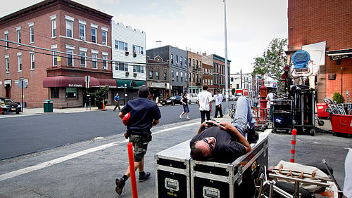
Filming is hard work. Vernon Blvd & 47th Rd, Long Island City. –Jesse Winter
If you’ve ever driven, biked, skateboarded, or walked down Vernon Blvd in LIC, chances are you’ve run into a few potholes… well no more! At least not on the blocks between 47th & 48th Aves. Hallejulah and praise a non-denominational deity: Vernon Blvd has been REPAVED.
Apparently we’re not the only ones excited, because NY1 has created a rather lengthy editorial video documenting the entire process, complete with community and politico commentary. Not to mention highly detailed information about how many tons of asphalt used and the number of DOT workers etc… seems they really want to be clear that they’re working hard for Long Island City.
While they’re at it »
Neighborhood
 Prev Entries